Climate Change:

Are we getting The Truth, The Whole Truth, and Nothing but The Truth?

The title of this essay is based on the guiding principles of our justice system. When presenting evidence in court, we are required to swear under some sort of oath, that we shall do just that. However, when it comes to evidence on the thorny subject of climate change, those principles are jettisoned in favour of ideological barrow-pushing by all sides of the debate. I am not a ‘climate scientist’, nor am I a ‘climate sceptic’, but I have had a thorough grounding in chemical, physical and biological sciences. For much of my early adult life I conducted research myself, and later, although I discontinued my career in research, I still worked very closely with many others who were actively involved in research. My background in a life of science has taught me to question what I read and hear, especially when there is so much apparently conflicting information. I have found, over the last few years, it has become increasingly difficult to determine who, if any, are right, and who are not. In this essay I shall identify such facts as I am able to in order to find out who is telling “The Truth, The Whole Truth, and Nothing but The Truth”, and who is not.

Here are four ‘truths’ that I am happy to believe and am prepared to accept.

  1. Atmospheric carbon dioxide levels are rising.
  2. Global temperatures are rising
  3. Polar ice caps and other glaciers are melting
  4. Sea levels are rising.

What I am not so certain about is the relationship between them, and that relationship therefore must be questioned. Do we have some chickens and eggs in this list?

Those most vocal, and those who are currently getting most air-time on radio and TV, and thus becoming more influential, seem to be pushing the line that there is a cause/effect relationship in the order in which I have listed the events. They are saying that the increasing CO2 levels are causing the increased temperatures, which in turn are causing the ice to melt, and hence increase the sea level. They are also saying that very soon it will reach a ‘tipping point’ from which there is no return, and catastrophic consequences will surely follow. They say we are already seeing glimpses of what is to come in the way of more severe floods and droughts, forest fires etc.Before we look for answers to the question of cause and effect, it is helpful I think, to first have a look at the earth itself, and then have a detailed look at the history of the climate for the last 18,000 years. To go back any further would be a waste of time, as it is 3 billion years or so of repeated cycles of warming and cooling, but not adding to our ability to predict what happens from now on!

As I understand it, the planet came into existence some 4.5 billion years ago, plus or minus a week or so, and probably on a Thursday afternoon. It is a roughly spherical ball of various materials, with a mass of something of the order of 6 X 1024 kg, or about 6,000 trillion tons. Much of it is covered by water, and the solid parts comprise an outer shell of loosely fitting slabs called tectonic plates, which slide about a bit on a core of less solid stuff, pushing up new mountain ranges as they bump into each other. It has a circumference at the equator of about 40,000km, and it revolves on a somewhat wobbly axis, once every 24 hours. That gives a speed of the order of 1,660 km/h at the equator, slightly in excess of the speed of sound (1,253km/h), and which is sufficient to cause the sphere to bulge in the equatorial region. In addition to that, the earth travels around the sun, a distance of some 940 million km at a speed of 11,000 km/h in an elliptical orbit, with enormous stresses as the curvature increases and decreases. The sun around which earth revolves is also an extremely dynamic ball of energy, with its own variations, all of which have their impact felt on earth. To add to these stresses, the moon pulls at it, continuously sloshing billions of tons of water about all over the planet. And then there are terrestrial volcanoes having various disruptive effects as the mood takes their fancy. Put simply, the earth might appear to be a solid, stable place to live, but it has to put up with an awful lot of stress, and it is totally unsurprising that its climate changes over millions of years with alternating hot and cold periods with varying durations and widely different extremes. And that is what has been noted and recorded. With all the possible sets of conditions and stresses, it is not possible to state with any precision exactly what causes these climatic conditions to change, or how long and frequent those changes may be. Suffice to say, the only thing constant is the change!

Now, a more detailed look at the last 18,000 years. We will pick up the story when the last of the major arctic ice sheets had already started receding and had shrunk to about as far south as London, give or take a mile or so. Quite what the change was that caused this shrinking we need not be too concerned about but whatever it was, it is absolutely guaranteed that it was not the burning of fossil fuels by Homo sapiens!  It probably had a lot to do with the sun, and/or terrestrial volcanic activity. The ice sheet continued to shrink as the ice melted, but initially the temperature did not rise. So here is an experiment you can do for yourselves. Put a couple of kilos of ice in a bucket with a couple of bottles of beer, or if you prefer, champagne, and leave it for an hour or so. You will find that the drink gets cold, and the ice begins to melt, but stick a thermometer in and you will find the water in the bucket is still at 0o C. Take out one bottle, remove the cap and enjoy an icy cold drink whilst leaving the other bottle in the bucket with the rest of the ice melting in the sun. The temperature of the water in the bucket remains at zero degrees until all of the ice has melted, and only then does it begin to rise. But once it starts to rise, it does so very quickly and within a very short time, the second bottle is too warm to be enjoyed. The reason is very simple. It takes 80 calories of energy to melt one gram of ice at 0o C to one gram of water at 0oC, but only one calorie is needed to warm up the one gram of water by one degree. So, the 2 kilos of ice will require 2000 X 80, = 160,000 calories to melt to water at zero, but only another 2000 x 10 = 20,000 calories to warm it up to 10o C. So, scale that up by factors of many millions and it is pretty obvious that a huge amount of extra energy would be required to melt ice caps well before there is excess energy to start warming the planet.

But of course, eventually that point is reached. As the ice cap shrinks the albedo effect (ie the reflection of incident energy away from the surface and back into space) decreases, so more energy is available to be absorbed. And further, as the ice shrinks, the land previously buried under the ice is exposed, and being much darker in colour than the ice, does absorb the energy more readily. Once that point is reached, then the temperature will increase. The next step in the sequence you will have noticed with your warm beer! Not only is it warm, but it also probably fizzed all over the table as soon as you opened it, and certainly became ‘flat’ very quickly. This is because the solubility of gases, including CO2, is inversely proportional to the temperature. As the temperature rises, so the CO2 is displaced and enters the atmosphere. Thus, the increase in CO2 follows after the temperature rise, rather than causing it.

So let us put the list into the new order:-

  1. Polar ice caps and other glaciers are melting
  2. Global temperatures are rising
  3. Atmospheric carbon dioxide levels are rising.
  4. Sea levels are rising.

Pretty much the opposite of the conventional narrative, and all we have done is to replace one too simplistic scenario with another, equally simplistic, but at least with a thinking based on very well-established principles of physics.

A very quick word about sea level rise. Certainly, melting ice will contribute to the sea level, but ONLY if it is land-based ice. Floating sea ice and icebergs are already 100% included in the sea level of the time, and do not add a single millimetre when they melt.  But the other factor that will increase the sea level is the thermal coefficient of expansion. For every degree that the sea warms, it will expand in accordance with the coefficient, and given the huge volume of sea water, even a small increase in temperature would be significant.

Now back to CO2 levels. Once the ice has melted and the land warms up, there will be a return of plant growth, which, of course, demands the photosynthesis of carbohydrates, a process by which CO2 is removed from the atmosphere. So on the one hand we have increasing CO2 thanks to the warming of the oceans, but on the other we have the removal of CO2 by the new plant life. So these factors will both have to be taken into account by those trying to tell us what is really happening.

Now we have seen the basics of what happens with climate change, even if we are not yet sure why, how or when each of the observed effects occur, let us pick up the story of the last 18,000 years.

Without any help or hindrance from Homo sapiens the arctic ice sheet continued to recede until about 1,000 years ago, in other words, for some 17,000 years until about 1,000 AD. By that time, the southern end of Greenland had become exposed from under the ice, and had become, as its name implies, a green and pleasant land. So green and pleasant that it attracted Vikings who came across in their boats from Scandinavia and established a colony there. They took with them some cows and lived very happily farming the land and drinking the milk for about 300 years. This was “the Medieval Warm Period”. The colony grew to about 3000 people, but the climate changed again, and at about 1,400 AD the “Little Ice Age” began, and the Vikings had to leave Greenland as it once again became a major ice sheet. This “Little Ice Age” with an average global temperature change of about 0.5 of a degree C lower than the preceding “Medieval warm Period” lasted until about 1,850, bringing us nicely to the Industrial Era, coinciding with the increased use of fossil fuels, starting in the early 19th century, and on-going.  

 So much for the “Truth”, but what about “The Whole Truth”?

  • Burning fossil fuels adds CO2 to the atmosphere
  • Increasing temperature adds CO2 to the atmosphere (due to decreased solubility in water)
  • Increased temperature leads to better plant growth, which takes CO2 out of the atmosphere
  • Better plant growth provides more food, and supports a growing population of Homo sapiens
  • More humans consume more food, and therefore put more CO2 back into the atmosphere

The net consequences of ALL of these truths need to be considered before simply blaming fossil fuels for the problems yet to come!

So whilst as we have seen CO2 concentrations do appear to be associated with temperature increases, and one can see why it is believed that there is a direct causal relationship, with CO2 being the culprit, there are other factors which are never spoken about, but which must be taken into account.

Let us have a look at the growth since 1800, of the global population of Homo sapiens. In 1800 the global population was just about 1.0 billion, and Thomas Robert Malthus (1766-1834) had already theorised that populations grow geometrically whilst food production grew arithmetically. Within 200 years, by 2,000, it had grown to just shy of 8.0 billion, a geometric progression of doubling every 70 years or so.  If that growth continues exponentially unabated, by 2070, a couple of decades beyond the date for which we have set the “net-zero target” for carbon emissions, the population will be of the order of 16 billion. Even if the increase is linear, the population will still have reached 10 or so billion.

The following graph shows very clearly how much more significant and dramatic the increase in population is, compared to the increase in temperature and CO2. But this never gets mentioned at all, despite it being by far the biggest elephant in the room!

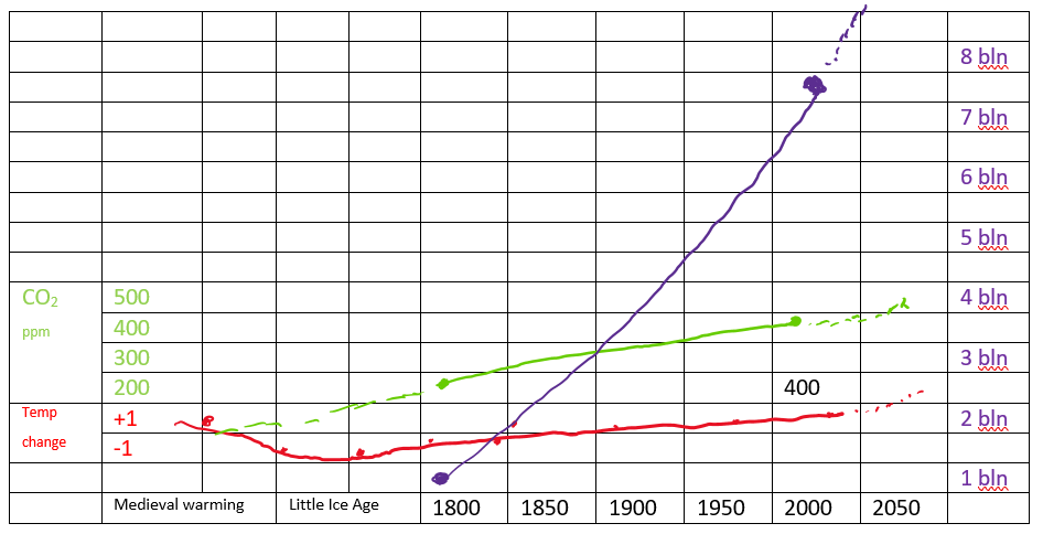
Population, billion (purple) temperature change +/- oC  (red)          Carbon Dioxide  parts/million (green)

Dotted lines are projections.

Now here is another truth that is never mentioned!  It is essential to understand that every single morsel of food that passes your lips, and the lips of your loved-ones, and of every single one of those billions of mouths, comes directly from the CO2 in the atmosphere! It has been the very fact of the increased emissions, and the increased temperature since 1800 that has enabled the population to grow as it has done for the last 200 years. Now today the activists and their acolytes are demanding a reduction in CO2. If such a step is brought about too quickly, the catastrophic famine and consequential starvation will result in a human death toll never seen before on the planet. If you believe that increasing atmospheric CO2 increases the temperature, you must also believe that decreasing that CO2 will lead to a decrease in temperature. That decrease in temperature will also enable the sea to absorb more CO2, leading to a greater decrease in global temperature. The decrease in CO2 and the decreased temperatures will combine to cause very significant decreases in the global production of food, leading to the mass starvation events just referred to. Thus, the effect of reduced CO2 and the consequential reduction of temperature will be far, far worse than the increase of one further degree currently predicted by 2050. In order to feed the ever-increasing population, we will need MORE, NOT LESS CO2 in the atmosphere.

It has been estimated that the production of one calorie of food carbohydrate consumes 5 to 6 calories of energy. Some calories come from the sun, and power the photosynthesis. The remaining calories are used in tilling the land, planting and then harvesting the crop, processing and transporting the food to where it is required, and in the manufacture and distribution of fertilisers to ensure maximum crop yields. All of that extra energy has to be generated somehow, and the most effective way is the use of fossil fuels, not least because that will also provide the additional CO2 that will be required as a substrate for the synthesis of carbohydrate food. We cannot allow even one year of crop failure. Two years would be catastrophic. 

One of the most under-recognised of all natural laws that govern the lives of Homo sapiens is the Law of Unintended Consequences. It is most likely that the reduction of atmospheric CO2 demanded by the Green Activists will have the unintended consequence of famine and starvation on an industrial scale, never before seen on Planet Earth. Activists such as Greta Thunberg, along with the various outspoken film ‘stars’, sports ‘stars’, Green politicians and the like should be demanding a major reduction in the reproduction of Homo sapiens rather than a halt to the use of fossil fuels. Banning fossil fuels without doing anything about the population growth which is the underlying cause of the insatiable need for energy, however generated, is a pointless exercise, unless one wishes to bring about mass famine and starvation.  

My parting advice is to warn you to be very careful what you wish for when you start demanding a reduction in carbon emissions. Today’s carbon emissions are tomorrow’s food!

Scientific Rambles Two

I had this blog pretty well ready to post on Wednesday but decided to save the draft and have one more read through on Thursday before posting. However, on Thursday I went to the shops intending to post the blog on my return, but got distracted, and as it turned out, the delay was to my slight advantage. Late on Wednesday, and again on Thursday, Dan said what I have been saying privately for ages, and what prompted this blog in the first place, namely, that lockdowns and restrictions will not ‘drive the numbers down’! So, with increased confidence that my premise is correct, even if my opinion on the actual mechanism is not quite correct, I shall now hit the ‘publish’ button and say publicly what has been in my mind for some time. Please read on!

For nearly two years now we have been in and out of lockdown as our political leaders grapple with the Covid 19 pandemic. They tell us that they take, and follow, the advice they receive from their chosen medical advisors; but each State and Territory appears to take a different approach, so I can only assume that medical opinion must vary, depending on which side of the State border the advisor’s salary originates. The recent emergence of the Delta strain is an interesting example of these differences. Gladys tells us over and over again, ad nauseum, that “the new Delta strain is the most infectious and dangerous strain yet”. And then she tries to flick it away with a feather duster, a strategy presumably advised, or at least approved, by her medical advisors. At the other extreme, Dan gets out and wields the baseball bat, again, presumably, on the advice of his advisors. So, the question is, ‘is either, neither or both strategies the most appropriate response”?

In my previous blog I indicated that in this one I would set out my opinion on the rise and fall of successive waves of covid infections, but in order to understand the theory, it is first necessary to have a bit of a grasp on the way genetics works. So, I shall start with some very rudimentary molecular genetics, which can be found in any number of school-level science books.

We all know that the genetic code for humans and all other forms of complex life is contained in their DNA. Fewer people will be aware that DNA comprises 4 relatively simple components called bases, known by the initial letter of each of their names, Adenine, Cytosine, Thymine,  and Guanine. They are arranged on a back-bone of deoxyribose, and the chains form a double helix, with C on one chain, paired with G on the other, and likewise, A and T are paired. In this illustration I have shown here only 6 bases in each strand, but in reality, they are many thousands of bases long, and contain every scrap of information required for life.

As well as ‘stop’ and ‘start’ signals, punctuation marks and so forth, triplet groups of consecutive bases code for each of the 21 or so amino acids that comprise our proteins. Thus, such a sequence might be A-C-T-G-T-T-C-G-A-T-A-G- (etc etc hundreds of bases long), with each group of three representing one amino acid. Now, if we take the same sequence but change just one base in the whole string thus, A-C-T-G-G-T-C-G-A-T-A-G- a different amino acid will be inserted into the protein, resulting in its having properties different to the original. In other words, a variant is created.

Before I leave the DNA, I will just explain that DNA is replicated in our cells when they divide so each of the new cells will have a complete copy of the entire genome.  Genome copying is carried out by the DNA-dependant DNA polymerase enzyme. ‘DNA polymerase’ refers to the enzyme’s ability to assemble or polymerise new DNA strands and ‘DNA-dependant’ means it does this using the existing DNA as a template. But to unlock the code and translate it into protein, it must first be transcribed into an RNA ‘messenger’, referred to as mRNA. This is facilitated by the enzyme DNA-dependant RNA polymerase. The mRNA is picked up by sub-cellular organelles called ribosomes, which effect the translation into protein.

Human DNA is a very stable double-stranded molecule, and accordingly variations (ie, base substitutions) are relatively rare.

Now, back to Covid!  Covid 19 is one of the very many ‘coronaviruses’, all of which have single-stranded RNA (note, not DNA) as their genetic material. This RNA is wrapped in a complex coat of lipids and proteins, including the much-referred to “spike protein” along with the less-referred to RNA-dependant RNA polymerase enzyme, which is also encoded in the RNA. This is absolutely essential to the replication of the virus, as our cells do not have an in-house supply of RNA-dependant RNA polymerase, without which, the virus cannot replicate. Hopefully that it not too confusing!

So, the Covid 19 virus has a single strand of RNA as its code; essentially the same make-up as DNA but the bases are on a backbone of Ribose (hence RNA), rather than Deoxyribose (DNA). The other difference, which is not significant here, is that three of the bases in RNA are the same A, C, and G, but the fourth is U rather than T. But the triplet groupings are still the codes for the amino acids. And when the virus infects a cell, the RNA is uncoated, it gets copied by the RNA-dependant RNA polymerase that the virus brought with it, and then behaves exactly the same as the normal cellular mRNA. That is to say, it gets picked up by a ribosome and translated into virus proteins including more of the polymerase enzyme. When there is the right mix of new viral RNA and proteins, they get assembled into complete progeny viruses, the cell breaks down, and the new virus particles are released to go and infect the next victim. (This intra-cellular translation of viral RNA to viral proteins is at the core of the Pfizer mRNA vaccine).

Now, the RNA-dependant RNA polymerase that the virus uses to copy its genome is more prone to introducing errors during copying than the DNA-dependant DNA polymerase our cells use and, unlike our cells, the virus does not have any means of correcting these errors. It is therefore far more likely that a wrong base will be inserted at some point in the viral genome each time the RNA is copied. That is to say, base “substitutions” can occur, leading to a different amino acid being used at one spot in the amino acid sequence resulting in a slightly different protein. Thus a ‘new variant’ is created. For the most part, these variant proteins make no difference to the virus so they are not of concern. Alternatively, they can be detrimental to the viral replication so we never see these particular variants in the community. Very occasionally, however, the protein change creates a variant that replicates better than the original virus or has other properties that aid its transmission from one person to another. These get labelled alpha, beta, gamma, delta and so on as the “Variants of Concern”.

Back to the Delta strain. This arose in India, and for some weeks a month or so ago, our news was full of the problems caused by Delta in India. We heard tales of woe from Australian citizens trapped in India and unable to return home. We were treated to much footage on television of funeral pyres in public parks and on the beaches, and we saw the devastating effects on an overwhelmed health system. Infections seemed to be spreading like wild-fire. But then, suddenly, and for no immediately apparent reason, India seemed to be no longer newsworthy, and it all disappeared from our television screens. At about the same time as this ‘disappearance’ of India, we found Delta here in Australia. As I mentioned in my opening paragraph, we were repeatedly told it was the “much more dangerous Delta strain”, as numbers rose despite the feather duster wielded by Gladys and the baseball bat swung about by Dan.

But what did happen in India, and what happened to the earlier “Variants of Concern” such as Alpha, Beta and Gamma?

This graph of Delta cases in India shows it very well

It is very clear that the kick-off in March 2021 was followed by huge growth in numbers until mid-May at which time the numbers started to fall; and they then fell at about the same rate as the rise, until they reached the original plateau by late June/early July. This fall can in no way be attributed to vaccinations, to the development of ‘herd immunity’, to lock-downs, to social distancing or to any other strategy. Co-incidentally, it was when the numbers started to fall that interest in the media seemed to wane along with the numbers.

My interpretation is that the same process of base substitution that leads to the emergence of the ‘Variants of Concern’ which cause so much havoc, is exactly the self-destructive process that leads to the demise of the variant. This degradation starts during the initial rise in infections and continues throughout the whole cycle to the end of the wave. It is when the number of defective progeny viruses of each infection cycle begins to exceed the number of non-degraded progeny that the numbers start to fall, each cycle from then on producing increasing numbers of defective progeny until the wave comes to it natural end. One hopes that we then get some breathing space before the next Variant of Concern appears.

The mutations most likely to bring about the demise of a variant strain would be those that cause a piece to be missing from the part of the RNA that codes for the RNA Polymerase enzyme, leading to the production of a dysfunctional enzyme incapable of replicating the RNA. Consider the following sequence of events.

A cell is infected with normal virus and begins its replication. At some stage during the virus replication in a cell, a mutation occurs within the gene that encodes the RNA polymerase protein leading to a deletion of part of that sequence.  Such mutations have been seen to occur in Coronavirus replication. When the virus particles are assembled, some will include the correct polymerase and some will include the defective polymerase. When the virus particles are released, a mixture of viruses with normal and defective polymerase enzymes may infect subsequent cells. The defective particles are incapable of producing the enzyme to replicate their RNA, but copies of that RNA can be replicated by the polymerase of the non-defective viruses. As the defective genome is slightly shorter than the normal genome it can be replicated faster and so there will be a slight increase in the proportion of defective genomes each time the virus replicates in new cells. Similarly, when the viruses are spread between people in the community, it is likely that they will be a mixture of non-defective and defective particles. The proportion of defective particles will increase over time as the defective genomes become dominant, and the process continues until eventually 50% of the progeny contain the defective genome and the wave begins to subside, as is shown in the above graphs. Note in the Australian graph, the delta curve is still heading north, but as I said in the Rambles One, it will not be long before the numbers head south!

Such a process not only attempts to explain why variant strains come and go as the Delta strain has in India, but it could also explain the ‘mystery’ of viral fragments turning up in wastewater even when no case has been detected. The degraded particles I have described are still infectious but are unable to replicate unless the cells are simultaneously infected with normal virus. But there will be occasions, particularly late in the wave, where people could be infected with only the degraded virus. These people would produce viral protein as normal, which they will shed into wastewater, but they will be the last of the line in that they cannot infect any more people. The PCR test which relies on detecting RNA will give negative results, and so the presence of the fragments remains a ‘mystery’.

So, what does it mean for us? I think that whilst it is not impossible, the number of infections currently in Australia is likely to be too small to create our own home-grown “Variants of Concern”, so our problems will continue to be imported variants escaping from quarantine. Following from that, it is clear that any traveller coming to Australia who has been infected overseas during the upward part of the curve will be bringing a very infectious virus, and our response should be swift and draconian because the wave could be vicious. However, someone arriving having been infected overseas during the downward part of the curve, would pose much less of a threat as the virus has already undergone a good deal of degradation by that time. Genomic sequencing, currently used to try to link cases, would be a very useful tool in determining how far the newly arrived infection has changed since the emergence of the Variant. This would further provide an estimate of how long the outbreak is likely to last.

The greatest threat will come from a new “Variant of Concern” that is so different, that our current vaccines might not afford the best immunity. In my explanations above, whilst concentrating on a mutation specifically effecting the RNA polymerase, I have referred to on-going mutations that could cause “Variants of Interest” to emerge, taking the full genome further away from the original. Now, suppose that toward the end of the natural life of any “Variant of Concern”, brought about by the defect in the polymerase, Sod’s Law was invoked, the original substitution reversed, and resulted in the repair and restoration of the polymerase to its proper and effective state. We now, suddenly, have a fully-functioning replicating genome ready to start making infectious progeny that are far enough removed from the original to earn its own status as a “new Variant of Concern”—-which will no doubt also earn the epithet of being “more dangerous and infectious than any previous variant”.

This is where the tweaking of the mRNA vaccines to keep up with the changes in the virus will be so important, and I would be pretty confident that Pfizer and others will already be working on that. However, it also means that we must continue to push ahead at the fullest speed possible with our vaccination programme, even when our current wave of Delta comes to its natural downward trend. That is to say, we must not become complacent. It is also vital that we push ahead with the development and construction of properly designed quarantine facilities to ensure that imported variants of concern cannot escape into the community.

Having said all of that, we could also take heart from the fact that the so-called “Spanish Flu” pandemic of one hundred years ago came to its natural end within two-three years with no help from vaccines, high-tech clinical interventions, lock-downs etc. Admittedly it claimed between 50 and 100 million lives from a global population of only 1.6 billion before it fizzled out, possibly by a mechanism not unlike the one I have described here by which our Variants of Concern have fizzled. (Bear in mind that flu is also an RNA virus). But of course, it also could have been due to the development of ‘herd immunity’ since there was very little done in those days to reduce the spread. So far, Covid has claimed just under 5 million lives from a global total population of the order of 7.8 billion—-so we are getting out of this pandemic rather lightly compared to 100 years ago!

Whilst the basic DNA and RNA chemistry described above is very standard stuff to be found in any number of text books and journals, the mechanisms I have described by which the Covid variants such as Delta disappear are my opinions, developed by applying my own reasoning based on my experience with the RNA polymerase of influenza virus, and what I have gleaned from information already the public domain. I have no new evidence to support the theory, and I am certainly not stating it as established fact. However, I am a little miffed at the reluctance of our political leaders to admit that the most significant contributor to the end of the wave is probably the virus itself! If anyone reading this has any other view on the rise and fall of covid waves, or if you find anything not quite clear, I would love to hear from you. I think you can leave comments on the blog site.

Scientific Rambles 1

Since we are not allowed to travel right now due to the Covid-19 Pandemic, I thought I would actually write something about the problem. So here is the first of my “Scientific Rambles”, being a sketch of where we are, what we think we know about it all, and how it might all pan out in the end.

I have shown below a graph taken from a trusted website (health.gov.au) which shows the trajectory of each of the waves of Covid infections we have so far had in Australia, up to today (August 28, 2021).

It is interesting to note that each wave has risen sharply, reached a peak, and then subsided just as sharply as it went up. Between the waves, infections have remained constantly very low. For nearly two years now, not a day has passed on which we have not been told something about Covid. A constant stream of politicians (who would be expert epidemiologists) has occupied hours of our television and radio news and current affairs time. And not far behind them has been a stream of expert epidemiologists (who would be politicians), filling in the rest of the news. But what have we actually learnt? Each time a new wave starts we are told that it is a ‘new and highly infectious variant’ and that we must have restrictions and go into lock-down in order to ‘drive down the numbers and get on top of it’. And sure enough, the numbers do drop; the political and epidemiological experts congratulate each other, and thank us all for the efforts and sacrifices we have all made to get the numbers down. The lock-down ends and the restrictions are eased, and the numbers remain low—-for a couple of months following the first wave, and for about 9 months following the second. The third wave is still at, or near, its peak, but I wager it will subside as quickly as it went up very shortly.

No explanation is given for the precipitous decline in numbers (other than ‘the success of the lock-down strategy’), or for the very low plateau. But again, when the third wave started, we were told that it is “the highly infectious new (Delta) strain”. Instant panic on the part of the politicians and the epidemiologists, and we are in lock-down again, following advice from the ‘Modelers’ in the ivory towers of biomedical research. Now don’t get me wrong—I have the highest respect for our biomedical, and all other, research workers. But the models rely on assumptions, and if they are not quite right, then neither will be the predictions. Having listened to a recent podcast by a very prominent health journalist, it seemed to me that one crucially important factor is missing from the assumptions, and that is related to the reasons for the collapse of the waves, and the failure of a wave to raise itself up again from its own ashes; that is, the bit we are never told about. That no-one ever mentions!

Now I can’t believe that our top virologists have no idea why the waves end and stay down as they do until a new variant comes along. I have read one report which claims it is simple Darwinian natural selection—-but I am not convinced that viruses are natural competitors in the way that Darwin had in mind; and I cannot accept that the emergence of a new strain necessarily prevents the earlier one from infecting people. I read another report claiming that ‘scientists are baffled by the decline and fall of the waves’, but as I said before, I cannot believe that our top virologists are ‘baffled’ to that extent.

So, once again the question “what is going on?”

In the absence of any other information, I am going to try to provide an explanation which I think is a real possibility—-but for which I admit I have scant evidence. Maybe the real experts will look askance at my efforts, but if so, I hope that they might actually then try to provide a better explanation; one that might be helpful to those who are trying to guide us through the pandemic. So far, it seems to me to be a gaping hole in the collective knowledge about Covid.  

My belief is (and by definition a belief is something one holds to be true despite the total lack of evidence) that the very mechanism that gives rise to each of the many variants of covid, is the very mechanism by which each variant enjoys its rapid rise to fame in a wave, before collapsing, never to rise again. In other words, each new variant has an inbuilt self-destruct mechanism that necessarily leads to its downfall—-a bit like the central character in a Shakespearean tragedy.

Now, you might like to dwell on this thought as you await the next edition of Slingsby’s Miscellany, which, in a couple of days, will include a blog with the grand title of “Scientific Rambles 2”, and in which the main body of the theory will be set out.

Sketches of Yarragon, Three

Our next ‘day out’ as part of our Yarragon Experience was to drive through the Strzelecki Hills, to the south of Yarragon. The ‘Old Leongatha Road’ that we started on (after our customary coffee in Yarragon) took us through pastures across the valley floor, before climbing quite steeply into the Strzelecki ranges. We then turned on to the Allambee-Childers Road, which seemed to follow the contour of the hills, becoming very winding, with occasional glimpses across the valley toward Mt Baw Baw. This part of the drive was through the Childers Plantations of eucalypts destined for the logging industry in due course. After leaving the plantations, we were driving through what was very probably potato crops until we reached Childers—a small domain comprising half a dozen scattered dwellings and farm buildings. Apart from the plantation areas, and the very occasional gully containing some vestiges of the original vegetation, it was hard to imagine what the area might have looked like to the original settlers. It was very interesting, and somewhat sad, to read that one tree felled in the 1880s, now known as the Cornthwaite Tree, measured 114 metres tall, and still holds the record of being the tallest flowering plant on the planet. Much is now made of The Ada Tree (near Powelltown) which is 75 metres tall and estimated to be 300 years old. If one uses simple arithmetic, assuming growth to have been linear over the years, the Cornthwaite Tree could well have been over 400 years old when it was felled in the 1880s; and already the size that the Ada Tree is now when Captain Cook discovered Australia in 1770. Quite likely, the Cornthwaite Tree was a sapling when Shakespeare was writing his plays! It had survived centuries of drought and fires, only to be hewn down by a logger’s axe, and the spot it stood upon turned into a field for growing potatoes, which plant had not even been introduced into England whilst the tree was yet a sapling in 1584! All that remains now is a small stone monument holding a commemorative plaque, and an information board at the roadside adjacent to a potato field.  

Site of the Cornthwaite Tree

The area was first settled in the 1870s, on the old stock route from Lang Lang to the south of the hills, to Moe on the north side. However, most of the traffic was from Moe, resulting in the track from the Lang Lang direction to Thorpdale soon becoming overgrown and unpassable. Land selection began in 1873, and as more settlers arrived, a post office was opened in 1879, known then as Narracan West. It was renamed Thorpdale in 1884 and continued in operation until being closed in 1968. The present town of Thorpdale, some 2 kilometres north of the old town, was founded in 1888 following the establishment of a spur railway line from Moe. A new Thorpdale post office opened in the new town in 1888 near the railway station, but the line was eventually closed, like most others in this part of the state, in 1958. At its height, Thorpdale was the business centre for all the farming activity that surrounded it. However, as road transport became the norm, many families, even those of the farmers, chose to move to the nearby towns of Trafalgar, Yarragon or Moe, and the town began to shrink. The local population is now about 470. There is a pub, but that seems to be open only on certain days of the week and was closed when we were there. However, there is a post office/general store/bakery/café, that makes very good coffee and cakes! Where the original railway station stood is now the local bowls club, and close by that is a well-developed Pioneer Park, with information boards, and a plaque for each of the pioneering families which opened up the area.

Thorpdale Village Store and cafe

Nearby, are the pretty Narracan Falls, a long-time favourite picnic area for local people.

Narracan Falls

From the falls, we wended our way back to the Highway, stopping at the roadside Potato Shed for some provisions on our way back to Yarragon. And so ended our trip onto the slopes of the Strzelecki ranges.

Our next ‘outing’ took us to Healesville to have a birthday lunch with our family, two of whom turned another year older whilst we were away. The firsts part of the journey was essentially a return to Neerim South, but then veering to the north rather than to the south. This route took us to the small township of Powelltown , in the Yarra Ranges Shire. The area was first settled in 1901 when a Mr Blake founded a timber yard and sawmill to provide the timber to fill government contracts. The mill was later bought by the Victorian Powell Wood Processing Company, and the township which had grown up around it was renamed Powelltown. Unlike many other timber towns such as Noojee, no railway was built to service Powelltown, so a simple tramway was constructed to take the timber to the rail-heads at Yarra Junction and Warburton. The tramway remained in service until 1945, and today, many of the old timber trails have been opened up as hiking routes. The Powelltown Pub is well worth a visit; it has an extensive multi-level veranda out the back, and at least one of the locals will make you very welcome!

Powelltown Pub
Powelltown Resident

After a coffee at the Powelltown pub, (it was a bit too early for a beer!), we continued on our way, stopping briefly at Yarra Junction on the Warburton Highway. Having been only in very small, out of- the-way villages for nearly a week, it was amazing how noisy Yarra Junction seemed to be! Trucks, cars, and streams of motorcycles thundered through the town, and to be honest, we found it quite unpleasant. So we did not tarry there long, but continued, through Launching Place, to Healesville.

Arrived at Healesville, we had little trouble finding parking and then the restaurant at which we to catch up with the family. A very pleasant meal and a glass of the local micro-brewery beer, and it was time to wander around. I had heard that there was a whisky distillery at Healseville, and I thought it must be the place one sees as one enters the town from the city end. However, that turned out to be a gin distillery (equally acceptable!), so I had to look further. I then spotted a ‘Distillery Lane’, towards which I bent my steps in the hope that I would indeed find the right place. However, I discovered there was a distillery, but it was closed—–probably due to the Covid Pandemic. But a lady who kept her own bees, made her own honey, and sold it from a small outlet adjacent to distillery assured me that it would re-open when the time was right. She also indicated that yes, they did make a good whisky, but as it needed to mature for a few years, it was not yet available! But at least I was on the right track, even if a few years too early! I shall have to return in the fulness of time.

By now it was time to farewell the family to go their separate ways, and we set our car in the direction of Neerim South once more, retracing the route we had taken earlier to get to Healesville. The weather being still and mild, there was a level of ‘planned burning’ happening, and the air was a little smoky. But it did give a certain redness to the sky.

Controlled Burning around Neerim

Just out of Neerim South we spotted a sign pointing the way to the Tarago River Reservoir, so we decided to have a look. I recalled fishing in this lake some 45 years ago, but had never returned—so today was the day. However, when we got down the valley to the reserve, we found that the lake itself was now protected by a chain-link cyclone fence, about 4 metres high, and one could just see the water from about 50 metres distance—and that was as close as one was allowed to get!

Tarago River Reservoir

So, back into the car and away to Yarragon we went.

Sunday morning, and it was time to say goodbye to our host, and to Yarragon, and head toward Melbourne. But on the way, we stopped in Warragul for some lunch, and to attend a recital of Bach’s cello suites, performed by a friend of ours, Joan Evans. Now I am not the most active member of the Bach Fan Club, in fact, I am not a member at all. Five of the 6 suites were played beautifully, and I am sure that had Joan owned the necessary (rare) five-string cello, all 6 would have been played, and enjoyed by the whole audience. But we made do with just the first five, which even so was a marathon for Joan, as it takes nearly 2 hours to play them. So, even though I am not a Bach fan, it was very wonderful to have the opportunity to hear this remarkable music played live, before an appreciative audience. It was a really lovely way to end our short visit to the Latrobe Valley and the environs of Yarragon.

As international travel will be off the agenda for quite some time, we plan to take a few more of these short trips away. Next time we might be really adventurous and head to Broadmeadows, then on to Kilmore, and we might even make it as far north as Seymour!

Sketches of Yarragon; Two

The first full day completed, and followed by some very good rest, we awoke to another very misty morning, which showed promise of being another beautiful day. We thought it would be a perfect day to traverse the valley and reach the top of Mount Baw Baw. However, a rather sluggish start and a leisurely coffee in Yarragon before actually heading off led us to think that maybe we might not achieve that lofty goal. Anyway, we set off heading for Neerim South as our first destination. I had been to this small town some 20 years ago, on a consultancy on which I was engaged, but did not then have time for sight-seeing, so it was as though we were seeing the countryside for the first time. And it was stunning! The rolling hills, covered in brilliant green grass, (even if not that long), with here and there clumps of deciduous trees in their finest autumn colours, all bathed in gentle sunlight, made for a perfect country drive. Traffic was light and we just poodled along like the retired couple we are. We had been told that there was a rail trestle bridge at Noojee that was worth looking at, and our plan, if we had one, was to stop in Neerim South for some lunch and then drive on to Noojee. However, before we reached Neerim, we spotted a sign for a “Trestle Bridge, 300m on left”. Thinking this must be the bridge we had been told about, we dutifully turned left, and found ourselves in the very small parking area for a very small bridge. At first we couldn’t even see the bridge, because it was under the road on which we were standing, and very over-grown with all sorts of vegetation.

Rokeby/Crossover Bridge

But a signboard in its place soon revealed that this was not the Noojee Bridge, but the Rokeby/ Crossover Bridge, which was closed to road traffic in 2004 after being deemed unsafe. It had been in use as a bridge since the rail cutting was constructed in 1892 as part of the line from Warragul to Neerim, but a re-alignment of the road made it redundant, and it fell into disrepair.

A group of local enthusiasts, the Rokeby and Crossover Friends Group, are raising awareness of the historic importance of this bridge to the local economy and are raising funds with a view to a restoration at some time before it deteriorates too far. Whilst it is a small bridge, the rail network in this part of Victoria was integral to the progress of the local area, and the bridge an essential part of that. So it is a very worthy cause.

Having stretched our legs taking a short wander through the bush at the bridge site, we moved on to Neerim South, and enjoyed a good coffee and a meat pie in the local bakery/café, before heading off to find the big bridge at Noojee. The drive for this part of our trip was through more rolling pastures, until we met and joined the Mt Baw Baw Tourist Road, where we turned right. A short distance later we passed the Alpine Trout Farm, which unfortunately was closed; a nice trout or two would have made a nice dinner for the evening! So, we continued without stopping, through some bush land and we soon spotted a sign “Historic Bridge, 300m on Right”. Turning into the carpark, we could see the bridge right in front of us—-and it is huge! The photo below shows only one half of the bridge. It would have been great to see an old K-Class steam engine rattling across with half a dozen carriages behind. There were a couple of very good information boards providing all the details of the bridge. It is one of seven bridges on the 46km Warragul – Noojee line, and was constructed between 1917 and 1919 to complete the rail service between those towns. Started in 1889, the line went only as far as Rokeby as its first stage. In 1892, it was extended to Neerim South; in 1917 it was extended to Nayook; and two years later, with the construction of this bridge, it reached Noojee. 

At the time, it was one of the largest such bridges in the southern hemisphere.

It is 21 metres tall, 107 meters in length, and comprises 19 trestles. At its peak in 1943, there were two trains each day between Noojee and Warragul, travelling at speeds up to 40 kph, with a third available should it be required. However, by 1948 rail services decreased as road transport became more financially viable. A special passenger train ran on March 3, 1954 to take local residents to Warragul for the visit of the recently crowned Queen Elizabeth ll, but three weeks later, one of the bridges was damaged by fire, and the Nayook to Noojee section of the line, which included this bridge, was closed. The rest of the line, from Warragul to Nayook continued in service until being closed in 1958. Between 1959 and 1961 the infrastructure of the rail line was removed except this bridge, which the Buln Buln Shire purchased for £1. As no maintenance was carried out on the bridge for several years, it deteriorated to the point where it had to be closed even to pedestrian traffic. However, in the 1990’s a report recommended some structural reinforcements, which were implemented, and by late 1996, it had been restored to its former glory as a reminder of its importance to the area. It has since become a major tourist attraction, and some 10,000 people visit each year. It hosts an annual “Longest Lunch” and is frequently used as a venue for weddings and other celebrations. If you find yourself in the region, it is very worthwhile making a detour to see it.

It is interesting to note that whilst the car park was empty when we arrived, within about 5 minutes four more had arrived. Chatting with the occupants of one, we discovered that they had driven from Melbourne for the very purpose of visiting the bridge. It was even more interesting to find that they live less than half a kilometre from where we live!

The Top of Noojee Bridge

After enjoying a steep climb up to the rail-trail, and across the bridge, we continued on our way to Noojee.

Arrived at Noojee, we found it to be a delightful village, on the banks of the La Trobe River. It comprises a few houses, sufficient to accommodate the population of 170 or so residents, a café, a pub and a few accommodation establishments. There is also a Heritage Centre at the site of the original rail terminus, which has quite a lot of railway equipment and memorabilia, but we had strolled too long around the area of the river, and it was closed by the time we got there! The river itself is very picturesque as it flows through a nice park in the centre of the village. First settled in the 1880s following the discovery of gold in the area, it became a major timber town when the railway arrived in 1919, as previously mentioned. The town was destroyed by fire in 1926, and again in the Black Friday fires of 1939. The only building left standing after the fires was the pub, which served as an emergency community meeting point during the fires, and as the school after the one-room school was destroyed.

At this point, we realised we definitely would not make it to the top of Mt Baw Baw, so we turned our wheels in the direction of Yarragon once more, not returning by the way we had come, but by continuing with the intention of joining the Fumina/Trafalgar Road. We were not far out of Noojee when we spotted a sign to Toorongo Falls, which of course we could not resist. It was a very pleasant drive, but much further than we thought it might have been. However, after going so far, we had to continue to the end—which turned out to be a further 10minute steep, rocky climb to a point where the falls might actually be visible. But, having left Ann in the car, I decided that the rapids I could see would suffice on the occasion. Maybe next time, we shall make sure we have more time available, and make it all the way!

Tooronga Falls

Having ‘done’ the Tooronga Falls, we again set off for Yarragon, by way of Tafalgar. I actually used the ‘sat nav’ for this stage, as we were running out of time, and did not want to go astray. The drive was essentially downhill most of the way, through timber land re-generated following the bush fires and the harvesting of timber. And it was a very pleasant, but very winding, drive. Eventually we reached the open rolling pastures again, driving through Fumina, Hill End and approaching Willow Grove.  And it was here that we spotted a large body of water off to our left, which tuned out to be Blue Rock Lake, and a very pretty place it was too!

Sign boards indicate that fishing and boating are permitted, but on this day, fortunately all was peace and tranquility. As Darryl Kerrigan would have said, had he been here rather than at Eildon “just look at the serenity”! I had seen signs to Blue Rock Lake in the past but had not known it was such a lovely place!

Back in the car, it was a short trip back to Yarragon by way of Trafalgar at the end of a lovely day out.

Sketches of Yarragon

Thanks to Covid 19, I have temporarily put the Vagabond project on hold, and instead, we are opportunistically visiting a few smaller centres in Victoria just for a few days of get-away time irrespective of whether The Vagabond ever visited! The first of these little jaunts is to Yarragon in Baw Baw Shire, just 75 minutes from home. It is a village that we have frequently passed through on our way to Lakes Entrance and other places, but at which we have never stopped for more than a cup of coffee and a wee break. True, I had a cousin living here whom we visited, but even then, we never ‘explored’ the region. So here we are, mid-April, on a very misty morning, staying at Rosewood Park on the northern slopes of the Strzelecki Ranges looking over the village of Yarragon toward Mt Baw Baw across the valley. Eventually the mist might clear, and we will actually be able to see Mt Baw Baw, but for the moment, we just imagine it to be there, because we have been told it is!.

Rosewood Park is a ten-acre patch of quite steep grassy paddocks wherein live six horses of various sizes and colours, including a 6-month old Brumby foal and his mother. I know very little about horses, but an authority, namely Bitzer, (Hard Times by Charles Dickens) tells us that horses are:- ‘Quadruped.  Graminivorous.  Forty teeth, namely twenty-four grinders, four eye-teeth, and twelve incisive.  Sheds coat in the spring; in marshy countries, sheds hoofs, too.  Hoofs hard, but requiring to be shod with iron.  Age known by marks in mouth.’  Thus, Bitzer. My own knowledge, also somewhat limited, stretches to the fact that an average size horse excretes about 20 kilos of pooh each day; and to sustain that output, appears to have an insatiable appetite for hay. In addition to the horses, we have seen a family of blue wrens, crimson and eastern rosellas, rainbow lorikeets, corellas, galahs, magpies, and of course, rabbits. The rose gardens are extensive, but are in a fairly dormant stage at this time of year.

The self-contained apartment itself was originally intended to be a “granny flat” for the builder’s mother, but is now let out by the current owner to couples such as us. It has a very generous dining/kitchen area, measuring some 6 metres by 9, and an integrated cozy lounge area with large north-facing windows. The bedroom is large, with a walk-in wardrobe; and a generously sized bathroom. The furnishings are very good and comfortable, and the kitchen well equipped, even including a balloon whisk. Breakfasts are provided in the shape of a basket of fresh eggs, a bag of mushrooms, a container of excellent bacon, a few tomatoes, and a loaf of excellent sourdough bread from the local baker. These are all replenished as soon as they are consumed. Tea, coffee, milk etc is also provided. At the other end of the building is a large covered BBQ area with suitable out-door furniture. All in all, it is an excellent retreat for a few quiet days away from the bustle of Melbourne.

It is a five-minute drive, down-hill all the way, to the village, which has a population of some 1,200. Many of the dwellings appear to be quite new, and there are certainly signs that the population is growing. As we entered the village on our first exploration, we encountered a ‘crocodile’ of some 40 five- and six-year-old children from the local primary school, on an expedition to count the number of shops in the one main street. Judging from the number of children, it is probably safe to assume that the adult population has a high level of fecundity, and that the population is destined to grow for some time to come.

Yarragon was originally a centre of timber harvesting and agriculture, mainly dairying; today it relies on agriculture and tourism. However, the Covid pandemic has taken its toll here, and several of the more ‘touristy’ shops are now closed, or are open only at weekends. Coffee shops and cafés appear to be doing well, or at least, are surviving. The main, in fact the only, shopping street, is on the south side of the Princes Highway, running parallel to it.

Main shopping strip of Yarragon

It is separated from the highway by a wide strip of grass running the whole length of the village and accommodating a public toilet, a picnic shelter, a War memorial, a rotunda, and a preserved K Class locomotive (in need of a little restoration!).

There is car parking on both sides of the road, and all the shops are on the south side. The railway line from Melbourne to Bairnsdale runs parallel to, and on the north side of, the highway. The station, now unmanned and used as an art gallery, was built in 1878, and the town, then known as Little Moe, sprang up around the station. The name was changed to Waterloo and a Post Office opened around October 1878. However, too much mail was incorrectly taken to Waterloo near Beaufort in the west of Victoria, so the village was renamed Yarragon in 1883. By 1893 there were 5 hotels, a hall, a school, a butter factory, and lots of shops along both sides of the Main Street which was at the time the main highway. However, changes came, the butter factory closed, and many shops became unsustainable and closed. Then the highway was re-aligned, and the grassy strip established, resulting in the current layout of the village. The fortunes of the village were re-started by the establishment of “Dairy Delicacies”, now known as “Gippsland Food and Wine” at the western end of the village street. There were plenty of empty shops available for cafes, arts and crafts, and the like to be established, and passing traffic to tap into. Slowly the town re-invented itself as a Tourist Town, albeit relying on the passing trade of those heading further afield, and was doing very well prior to Covid.

Today there is only one pub, which was established in 1926, in perhaps the only building of significance in the town. They serve very good food; and were obliging enough to turn off the huge TV screen which rather dominated the room in which we were dining!

What became of the original 5 pubs does not appear to be documented, but I guess they were demolished. To be honest, there is not much in the way of buildings in the main street that can be said to have any architectural merit!

 But much is made of the old K-class engine, No. K183.

K-class engine, K162, rebadged K 183

She was built in 1943, being one of 53 such engines built at Newport between 1922 and 1946. Like all the K-class engines, she was very reliable and had completed nearly 600,000km during her 25 years of active service, from which she retired in 1969. However, upon that ‘retirement’, she was transferred to ‘light duties’ in the Bendigo railway workshops, where she remained until 1976. In 1977 she was bought by the Narracan Shire and placed on display near the Yarragon railway station. Then, in 1982, Steamrail Victoria exchanged the unfit K162 (built in 1941) for the restorable K183, and she was towed to Melbourne where she was restored at a cost of $30,000, and returned to active service in 1992 hauling special excursion trains. Unfortunately, she was involved in a serious level-crossing accident in 2002, in which three people died and she herself was severely damaged and taken out of service for good. The engine on display at Yarragon is, in fact, the old K162, re-badged K183 in part to honour the original link between Yarragon and K183, and also because post-cards and other memorabilia had been produced by Yarragon traders with the original engine bearing the K183 plates. Only 4 K-class engines are still in active service (on tourist routes), and 7 are preserved in static displays. If you are interested in railway history, there is plenty in this region to excite, some of which will be included in the next blog.

Well, that sums up our first full day at Yarragon. The next blog will fill you in with some of the exploring we have done in the region.

Slingsby during the Covid Lock-down

It has been some while since I last posted a blog. To be precise, the last post was a Sketch of Nagambie in December 2019, when we visited that part of Victoria with our camping friends. But I have not been idle! I do have two blogs ready to be posted, but for which I am awaiting copyright permission. In the 1880s and 1890s, an expat English man who had several names, including, but not limited to, ‘John Stanley James’ and ‘Julian Thomas’, travelled around Victoria submitting to the Age and Argus newspapers short articles on each place he visited. These he submitted under the name of ‘The Vagabond’, and fairly recently they have been gathered together and compiled into two books by renowned Australian journalist and historian Michael Cannon.

The Vagabond

One book is entitled Vagabond Country which is a collection of his rural Victoria travels; the other entitled The Vagabond Papers comprises his Melbourne and Sydney urban sketches. I have embarked on the project of following the routes that the Vagabond travelled through Victoria and writing sketches of the same places as they are now, particularly noting the significant changes that have occurred over the last 130 or so years. So far, I have made a trip to Broadmeadows, which was his first trip, and to Kilmore, which was his second destination. These sketches are ready for publication in the Miscellany, but I am waiting for permission to quote fragments from Michael Cannon’s books. I am sure there will be no problems, but rules must be followed!

The third stop-over on the trail is to be Seymour; but our plans to visit that town in April of this year were thwarted by the arrival in Australia of Covid 19 and so the project has been temporarily postponed. However, that has given me an opportunity to revise some of the Miscellany, and you will now find an embryonic Menu, allowing easier access to ‘International’ and ‘Australian’ travel blogs. As I gain proficiency in finding my way around the arcane intricacies of the inner working of the blog site, I shall refine the menu to make it even easier—–I hope.

In the meantime, I thought I would bring you up to date with another project on which I have embarked due to Covid 19. Being ‘locked in’, or ‘locked down’, for the duration, I willingly accepted an invitation to try my hand at pre-recording ‘content’ that could be broadcast on Community Radio. Like many other enterprises, Community Radio stations have been caught up with the ‘social distancing’ and ‘work from home’ restrictions placed on all of us. Whilst many of the regular presenters have been willing, and able, to embrace the new processes, many of the usual volunteer program presenters do not have suitable recording facilities at their homes, leaving quite a few ‘unfilled’ time-slots in the daily broadcasts. As it happens, I do have some quite sophisticated recording and editing gear at home, (which I use in a rather amateurish way) and knowing this, the manager of Community Radio 3MDR (Mountain District Radio) asked if I would like to record some stuff. I had, in the past, filled in with a classical music program when the regular presenter was unavailable, so I thought ‘why not?’ My project began with a 30-minute segment reading poems by the late, great, bush poet Henry Lawson, which was broadcast on Tuesday April 21, and if you are at all interested, you may listen to it by clicking here. You will need to wait about 45 seconds before I come along!

For the second program I got a bit more adventurous and slotted some music between the readings. That program was broadcast on Tuesday April 28, and you may hear it by clicking here. This time, the scheduling got a bit out of whack, with the previous program running over by a few minutes; about 8 minutes and 40 seconds to be precise. However, you can drag the progress dot at the right-hand end player a bit to the right, until 8:45 shows just to the right of the speaker icon. This is a small and insignificant glitch in the scheme of things, and I think that we are lucky to get anything at all during these days of severe “Covid 19 lock-down”. So we must thank 3MDR and its dedicated staff for the efforts they are making on our behalf to keep the station on air!

Flushed with the success of slotting music between the readings, I then began including recordings of whole poems that had been set to music by various composers and sprinkling those among the readings. The third program was broadcast on May 19, and the link to that is here.  If you have enjoyed listening to Slingsby Browning on 3MDR, you might like to have a look at their program guide to see if there is anything else which takes your fancy.  Also, on that web page you will find details of other 3MDR activities, including how to become a subscriber. Depending on where you live, you may be able to tune in to 97.1fm to get to 3MDR; alternatively, you can listen live, or listen back, from the web page accessed by the program guide link above. Community radio depends on membership subscriptions, sponsorships by individuals, local community groups and businesses, and grants from charitable institutions. I think there is also a small amount of tax-payer funding allocated by the Commonwealth Government, but it is not an automatic grant, rather it has to be applied for. In addition to broadcasting content developed and produced by the volunteer presenters, 3MDR also provides work experience opportunities to high school students interested in a career in media or the technical aspects of sound in the entertainment industry. Further, being located adjacent to a local primary school, opportunities are frequently offered to primary school students to go ‘live’ on-air with various programs such as singing and storytelling. 3MDR is also a strong supporter of local musicians living and working in and around the Dandenong Ranges area, giving airplay to their recordings, promoting their gigs, and frequently providing opportunities for live-to-air broadcasts from the 3MDR studio. It has been a pleasure and great fun to provide ‘content’ during this time of Covid ‘lock-down’, and to be a part of the 3MDR endeavours.

Hopefully as the travel restrictions are lifted, we shall be able to get behind the wheel and once again head off to explore more of Victoria, following in the footsteps of The Vagabond. Until that happens, maybe a little ‘armchair travel’ reading some of the earlier blogs might help while away a few hours!


Sketches of Nagambie

Every town needs its hero, something to look up to, to make the town different from other towns. For the 1,860 or so people who live in Nagambie, their hero is the race horse Black Caviar. Born in 2006 at a stud somewhere around the Nagambie district, Black Caviar was undefeated in 25 races, including 15 Group One wins. Her honours included being named WTRR World Champion Sprinter in 2010, 2011, 2012 and 2013, and she earned her connections nearly $8 million before her retirement on April 17, 2013. Black Caviar is now honoured with a life-sized statue erected, just 6 months after her retirement, on the bank of Lake Nagambie near the centre of the town.

Black Caviar

The Nagambie district was first settled in the early 1830s, as it provided a suitable crossing point on the Goulburn River. Among the first buildings were of course a public house, a church, and a post office, all built in 1837. The church was nicely positioned near the bank of the Goulburn, and remained in use until June 2003, when a heavily loaded truck veered off the road and demolished it; fortunately, being a Monday, there was no-one in the church, and no-one was injured. There is a memorial plaque 30 metres to the left of the spot where the church once stood.

Monument to the destroyed Uniting Church

The Black Caviar statue now holds pride of place on the very spot once occupied by the church, 30 metres to the right of this monument, giving an indication of the God-like status that the horse holds in the town. Apparently breeding thoroughbred horses is still an important part of the local economy, but the only equine flesh we saw comprised an aging donkey and a couple of ponies with a physique more Thelwellian than that of a champion thoroughbred racehorse.

As well as horse breeding, major agricultural activities include vineyards and grain crops. There was an old saying, ‘Never mix the grape and the grain’, but in the Nagambie district, both products are produced and seem to co-exist quite happily. There are a couple of old, very well established wineries, Chateau Tahbilk, and Mitchelton. Both are open to the public, and both are important parts of the tourist industry with their wine sales, tours and restaurants. And of course they are major employers of both permanent and casual seasonal staff. In addition there are several other vineyards which would also be worth visiting.

Chateau Tahbilk

Having a limited time available to us, we managed to visit only one of the wineries, and chose Tahbilk as it was marginally closer. Established in 1860, it was purchased by Reginald Purbrick in 1925, and is still family-owned. Since buying the vineyards, five generations of Purbricks have been involved, with the latest three generations still very active. The original buildings, including extensive underground cellars, are still in use, and are classified by the National Trust. The grounds are very extensive, and include some large wetland reserves important for the local native flora and fauna. Whilst we were at this billabong we met some wild-life officers who had just installed several cameras as part of the survey of the populations of endangered species.

Billabong at Chateau Tahbilk

In addition to all the wineries, beer drinkers are also catered for by a new brewery recently opened in the centre of the town. Built adjacent to the site of the original 1870 Police Court and camp, it not only makes a very nice beer, it also has a nice deck, which is an extension of the restaurant overlooking the lake, where one may sit and taste the fruits of the brewer’s labours.

Deck at Nagambie Brewery

Nagambie Brewery

We understand that the brewery also includes a distillery, and is planning to produce a gin in the near future.

Lake Nagambie is the result of damming the Goulburn River in the 1880s. Just one dam wall across the Goulburn created a number of lakes and connecting waterways, which look, on the map, like the entrails of an eviscerated mythical monster.

Map of Nagambie Lakes

These lakes and waterways have become a boatie’s paradise, and in addition to the primary reason for damming the Goulburn, which of course was irrigation, they are a huge part of the tourist industry. Water activities include an eight-lane two kilometre stretch exclusively for rowing, and a large area exclusively for power boats and water skiing; and of course, fishing. Speed limits on the water appear to be enforced, and even though we are not interested in power boats and jet skis, we have to admit they were not too intrusive. We were staying in a cabin at the Nagambie Lakes Leisure Park, which park, despite being full almost to capacity, still provided a very peaceful and tranquil place to stay for a few days.

Goulburn River at Leisure Park

The town itself is quite small and compact, and sits right on the bank of the lake. With a resident population of some 1,860 people, it has one main street with shops, three pubs, a motel or two, a post office, several cafés, a butcher, a newsagent, and other miscellaneous commercial properties spread along it. There is a Mechanics Institute dating from 1873, a Historical Society dating from 1871, and a large modern supermarket. The main street, which has a nice tree-lined median strip, was the original route to Shepparton, but the town now has a major freeway by-pass, so there is little heavy traffic lumbering through; and car parking is not a problem.

Median Strip, Nagambie

When the town was initially bypassed, it fell into a decline for a few years, but is now reviving itself as a major tourist area, and its small size makes it a delightful place to visit. There are three churches remaining, all dating from the late 19th century, and all built of red bricks, and all much the same size—small.

St John’s Anglican Church, Nagambie

There are two Primary Schools in the town, one being a Catholic School, the other being a secular State School. Both schools appear to be well maintained. There was a ‘Cottage School’ in the late 19th century, but that now appears to be a private dwelling.

Old Cottage School, Nagambie

There is no Secondary or High School in the town, the nearest being in Shepparton, which can be easily reached by way of the V-Line train service which passes through Nagambie. Seymour, also on the V-Line route has a High School, but that is a little further to travel.

V-Line rails to Shepparton

There are some very pleasant older-style houses scattered around the residential streets, and several new housing estates are in the process of being developed. Whilst it is probably not a daily commutable distance from Melbourne, it is by no means isolated, with Melbourne only about 90 minute drive away along the Hume Freeway.

The surrounding area is very nice, and a drive of about 20 minutes will take you through some pleasant undulating country, through several vineyards, and over the very rickety, but perfectly safe Kirwans Bridge, to the Goulburn Weir.

Kirwans Bridge

Originally constructed in 1890 when flooding of the Goulburn valley due to construction of the weir submerged an earlier bridge, the 310 metre long Kirwans Bridge is the longest timber bridge in Victoria. Linking two Shires, it has had a chequered history, and there were frequent arguments between the Shire Councils at either end of the bridge on matters such as maintenance and repairs. A proposed second lane was abandoned in the 1950’s, leaving only two small bays on the bridge to allow for passing vehicles. Over the years it has been closed several times, the most recent closure being in 2010 for repairs initially estimated at $1.2M. At that price, it might well have remained closed forever, but a ‘second opinion’ was sought by the Kirwans Bridge Action Group, which resulted in the repairs being carried out over the ensuing 12 months for a mere $100,000. The bridge was reopened in 2011, with the ribbon being ceremoniously cut by the 88 year old local resident, Alice Thomas, from her motorised mobility scooter.

The Goulburn Weir, the oldest in Australia, immediately became a tourist attraction, as it was illuminated at night using hydroelectric power generated by a turbine in the outfall pipe. However, its raison d’être was as an important part of the irrigation system for the lower Goulburn valley. On average, 98% of the water released from Lake Eildon on the Upper Goulburn is diverted into the irrigation channels, leaving only the barest minimum stream flow in the river itself.

Goulburn Weir, with flow into irrigation channels

Weir, with trickle into the Goulburn River

Further downstream from the weir, lies the even smaller town of Murchison. Settled at about the same time as Nagambie, and for the same reason—a suitable crossing place, Murchison now has a population of the order of 950, a little over half that of Nagambie.

Main Street, Murchison

This photograph comprises almost all of the shops that are in the main street of Murchison. Opposite the shops on the bank of the river are some very nice town gardens with half a dozen or so unusual sculptures, of which this is a typical example.


Murchison’s Blue Cow

At this part, the river bed is some 9 or 10 metres below the town.

River bed at Murchison

Due to the weir, very little water now flows along the Goulburn River for most of the year. However, flood markers indicate that at times of exceptionally high rainfall, the weir probably saves the town from inundation.

Murchison Flood Marker

The worst flood was in 1916, at just over 12.2 metres; the most recent being 2010 at 10.15 metres.

In the 1870’s, there were six hotels, a couple of flour mills, and the town was pretty lively with other stores and services. But it couldn’t last forever, and it didn’t last for long. Prior to the construction of the weir, paddle steamers from the Murray River could reach Murchison, but the weir put an end to that, and the town soon declined in importance. However, it had a bit of resurgence in the 1940’s with the establishment of Prisoner of War camps holding approximately 4000 Italian, German and Japanese prisoners. The camps employed about 675 people, and the Italian and Japanese prisoners, but not the German, worked as fruit pickers on local farms. After the camps closed in 1947, one, Dhurringle, became a low-security prison. The Murchison Cemetery holds the remains of 130 Italian soldiers and civilians who died while interned in Australia.

Just as Nagambie has Black Caviar as its hero, Murchison has the Murchison Meteorite! On September 28, 1969, a meteorite shower fell to earth just south of Murchison. Hundreds of fragments of the meteorite have been found spread over a 35 square kilometre area, the largest fragment weighing in at about 7kg; a total weight of the order of 100kg has been found. However, most of the meteorite fragments are now in research facilities and museums across the world, and there is very little to see in Murchison.

The Murchison Meteorite has made a significant contribution to our understanding of extra-terrestrial chemistry. The meteorite belongs to the category known as carbonaceous chondrite, containing water and many organic chemicals, rather than just being rocky. The Murchison fragments contained 8% water, and traces of over 70 different amino acids (the building blocks of proteins). Of the 70 or so amino acids isolated from the meteorite fragments, only 19 are found naturally on earth. What is significant about these molecules is that they demonstrate that the simple chemical building blocks necessary for life on Earth, seem to form quite readily in other parts of the Universe.

A ‘Meteorite Park’ in the town centre celebrates this discovery; and there is a Historical Museum on the river bank which probably has a fragment or two. But we can’t be certain of that, as we didn’t actually manage to get into the museum.  We believe the lady in charge at the museum spotted us as we approached with about 10 minutes to go before closing time. We saw her nip out and retrieve the “Now Open” sign, and very smartly nip back in and lock the door, possibly so that we would not delay her leaving for the afternoon by asking endless questions about their heroic meteorite.

If you have two or three days to spare, and do not want to spend too much time travelling very far from Melbourne, Nagambie and the surrounding area is a very handy and interesting place to visit.


The Last Few Days in the UK

The flight back from Guernsey to England was delayed by an hour for no apparent reason, and as a consequence we had a very late dinner in Cranleigh. The following morning we were dropped off in Guildford and took the train from there to London, and thence to Margate. The English trains are very good; they are clean, quiet and comfortable, and seem to run on time. Maybe this has something to do with the right of passengers to receive compensation if the train is late. However, train travel is expensive; the one-way fare from Guildford to Margate via London was £50.00 (approx. $100.00) each. Of course that is in keeping with everything else. For the most part we were handing over pounds as though they were dollars, but each pound had cost us nearly two dollars to buy. One example is petrol—$1.30 per litre in Australia, £1.30 in England. Another good example is coffee. Not only was it generally lousy coffee, but we were paying between £3 and £3.50 ($6 to $7) a cup. But not all coffee was bad! Café G at the harbour end of Margate High Street still made excellent coffee. I always asked for ‘A long black, please’. In most places this met with a quizzical look on the face of the person at the counter, who generally asked whether I meant ‘an Americano?’ Well, no, that is not what I meant. An Americano is a large bowl-shaped cup containing a large quantity of luke-warm liquid, vaguely coffee coloured, but not tasting of anything in particular. I tried espresso, double espresso and various other offerings, but none compared very favourably with an Australian long black coffee. Apart from Café G in Margate, the only other place that understood the meaning of ‘long black’ was the Octopus Bar in Guernsey. At neither of these places did I have to try to explain what I meant—-the coffee was just made without question, and was very good.

I have written about Margate in earlier blogs, so I shall not say much more now—other than the slow demise of the High Street continues on its merry way. One of my favourite shops was Rook’s, which sold fresh meat and a wonderful selection of cheeses, meat pies, hams and other cold cooked meats. Since we were last in Kent, the Margate Rook’s has closed completely. But around the Harbour, Margate is still looking good. The Turner Centre has a lot to do with that, and this year the Turner Centre scored the coup of having the four finalists of the very prestigious “Turner Prize” exhibited there. We did not get to the exhibition as it didn’t open until after we left—but previous winners have always been controversial in that this particular prize pushes the boundaries of art way beyond what most people think of as ‘art’. A previous finalist was Tracy Emmin, who simply exhibited her unmade bed—-a bed that she had not vacated for some four or five days, and which was surrounded by unwashed clothes and other detritus. It sold recently for over £1.5M. There must be millions of parents who wish they could sell their teenager’s messy beds for a fraction of that. But as their beds were not exhibited in the Turner Prize, those beds would not be considered ‘art’ in the way that Emmin’s bed is!

There are a couple of other artistic/literary connections with Margate. One is that Ellen Ternan, a quondam friend of Charles Dickens, moved with her husband to Margate, where they established a school. The name of the road, College Road, is now the only reminder of that venture. Another literary link to Margate is that the poet T.S Elliot wrote part of his major poem The Waste Land whilst sitting in the Nayland Rock shelter during October and November, 1921. He was apparently in the area on sick leave from his day job, convalescing from some sort of nervous disorder. The Waste Land is widely regarded as one of the most important poems of the 20th century and a central work of modernist poetry . I must confess I found it a bit hard going!

The Nayland Rock Shelter

The Margate summer holiday season, which by all accounts was a pretty good one for the town, is now drawing to an end. Dreamland is preparing to close for the winter, and many of the amusements along the sea front have already closed. The beaches are deserted apart from the occasional dog-walker, and the beach huts are being hoisted on to trucks and removed to winter storages.

Removing the Beach Huts

But if the sun shines again next year, and the Turner Centre can keep bringing people to the area, maybe Margate will once again find its pot of gold somewhere near the harbour.

Rainbow over Margate Harbour

We returned to Herne Bay for the last few days, catching up with family and friends. We enjoyed a very nice meal at The Old Gate Inn, a rambling old building dating from 1728, which was originally a tollgate on the road to Dover, (not to be confused with The Gate Inn in the East Kent Marshes).

The Old Gate Inn, Canterbury

We also enjoyed a meal at The Punch Tavern, which, because if its location between Herne Bay and Canterbury, was originally called The Halfway House.

We made a trip to Ramsgate, which we had not visited on the last few trips to the UK. It is looking quite spruced up around the harbour; the old harbour-side casino has been fully refurbished and is now a Wetherspoon’s pub—-a much better use of the building than gambling.

The old casino, now Wetherspoon’s, Ramsgate

The décor is very nicely done, the beer is cheap, the food is good, and lunch on the outside balcony overlooking the beach was very pleasant. Just nearby is a monument to King George IV erected “…as a grateful record of his Majesty’s gracious condescension in selecting this port for his embarkation on the 25th September in progress to His Kingdom of Hanover and his happy return on the 8th November 1821”. A rather pompous inscription, I thought.

King George IV Monument

We then went for a stroll along the western cliff top, overlooking the end of the harbour and the open sea of Pegwell Bay. It was all very nicely gardened, and made for a very pleasant walk. Along the way we came across a sculpture of a pair of hands holding what from a distance looked like some juggling balls.

Monument to medicinal research

We could not resist a closer look, and found that it “celebrates the discovery, development and manufacture of innovative medicines in East Kent” —mainly by the pharmaceutical giant, Pfizer. We had both worked at Pfizer nearly 60 years ago, and in fact that is where we met—-in the polio vaccine testing laboratories; so we thought we had some proprietorial interest in this monument. On closer inspection, the ‘juggling balls’ turned out to be molecular model which bore more than a passing resemblance to a fragment of a tetracycline antibiotic, which family of antibiotics Pfizer was manufacturing at the Sandwich plant all those years ago. The Pfizer plant can just be seen beyond the sea to the left of Ann’s shoulder.

We went back to Canterbury, and whilst Ann was on a shopping spree with her sister-in law, I became a flâneur around the back streets, finding quaint spots and anabranches of the river Stour that I never knew existed.

Anabranch of the Stour in Canterbury

Fragments of the old city wall


I visited another of the ancient pubs, enjoyed a last pint of Shepherd Neame beer,

The Bishop’s Finger, Canterbury

then walked the five or so kilometres to Sturry, from where I caught a ‘triangle bus’ back to Herne Bay. The following day we took a nice walk along the cliffs at the edge of the marshes to the old Roman fort of Reculver. (Note; the towers in the photograph are not Roman, rather they are all that remains of the mediaeval Church of St Mary, and are owned by the Maritime Authorities as a navigation aid.). The Roman site is managed by The English Heritage; and the adjacent clifftops and marshes are classified as significant wildlife sanctuaries and nature reserves.

Reculver Towers

But our time in the UK couldn’t last for ever, and it didn’t last for long. All good things come to an end, and after 5 weeks and a half, it was now time to pack everything into the suit cases and head to Heathrow for the flight back home. It really was a great trip. Everything went according to our original plans, except for not making a trip to France to have a lunch with our granddaughter; but maybe another time, who can tell………?


Guernsey

The drive from Mylor Bridge to Southampton, a distance of the order of 400km took 8 hours! From home to Lakes Entrance, which is the same distance, it usually takes us half of that time! The road in both directions was nose-to-nose traffic for the entire 8 hours, but very rarely did we actually come to a complete stop, and just as rarely did we reach the designated speed limit, and we never managed to exceed it. Unbelievable!  And then, when we finally got to Southampton airport and through all the palaver of checking in, passports etc, the plane was an hour late.  But eventually we reached Guernsey, and it all seemed worthwhile. As we descended toward the airport, everything looked very neat and tidy, as it always does from a few hundred feet up. But in Guernsey, that neatness and tidiness was equally apparent at ground level. I do not think I have ever seen a place so well kept, and here was a whole island neat and tidy, with nothing out of place. A short wait for a taxi, and we were on our way to the Auberge du Val where we were to stay for the next three days.

Auberge du Val

Originally a farm house, it is full of character; and our host and hostess were charming and made us very welcome. There is a nice courtyard out the back where we sat with our pre-dinner drinks whilst we waited for a table–we had forborne making a booking for dinner as when we booked the room we were not sure when we would arrive. A charming elderly gentleman sharing the courtyard with us turned out to be a long-time resident of Guernsey, and he entertained us with stories of growing potatoes and tomatoes—which might not sound very thrilling, but which was in fact very interesting! Eventually we were called to our table, and enjoyed a rather excellent late dinner.

The Auberge du Val is about 20 minutes by bus from the main town of the island, St Peter Port, so that is how we travelled and where we went the next morning after a very good full Monty breakfast. There is one bus, the number 71, on this route, which is a full circle. And unlike the Triangle busses on the Canterbury/Whitstable/Herne Bay route which go both clock- and anti-clockwise, the number 71 only goes clockwise, so the return journey takes twice as long as it goes round the rest of the circle. St Peter Port is a very hilly and a very compact town, with a very nice harbour. Clearly it is a place which attracts those who like messing about in boats!

St Peter Port Harbor

But the particular point of interest we wanted to visit is the house in which Victor Hugo lived during his period of exile from France (1856 to 1870).

Victor Hugo’s House

To reach the house we had to climb a very steep street, and on arrival found that it is necessary to make a booking as they only admit visitors undertaking a conducted tour. However, a plea that we were from Australia, and had only a couple of days available to us fell on sympathetic ears, and we were offered a place on a tour about one hour and a half later —just enough time to climb about 50 more metres up the hill to the Pandora Hotel which had a rather lovely beer garden in which we could enjoy a couple of pints of local Guernsey beer.

The Garden at the Pandora Inn

When Charles Dickens visited Victor Hugo in his Paris apartment some years before his exile, he described Hugo as ‘looking like a genius, which of course he is’. He also described the apartment as looking ‘like a museum or a set from one of his plays’. There is no doubt that Hugo had a very peculiar approach to furnishing his accommodations! About one half of the rooms are very dark, with tapestries hanging on the walls and covering the ceilings, and at least one wall of each room made from very dark wood scavenged from ancient carved chests. The other half of the rooms were very light and airy, except for one which was hung with red drapes, and made to look like the set of a play. I found some of it too oppressive for my taste—but the young French woman who conducted us around gave a very informative commentary, highlighting Hugo’s idiosyncratic approach to his surroundings and to his writing. The house is owned, and run, by The Museum of Paris, having been bequeathed to the Museum by his descendants. The house also has a very nice walled garden, which is being re-planted with some of the plants known to have been there in the past. Well worth a visit if you find yourself on Guernsey.

Victor Hugo’s Garden

The following day we took a half-day bus tour of the island, which was excellent. Our driver/guide was a passionate resident of Guernsey, with an in-depth knowledge of the history of the Islands, and a great sense of humour. One of the things I noticed, and could not understand, was that as soon as we arrived on the island our English sim-card didn’t work. I have to confess that I always thought of the Channel Islands as being a part of the UK; I knew they were not part of France, despite their proximity to that country. Our tour guide then made it all clear. It appears that when William, the Duke of Normandy, invaded and conquered England in 1066, the Channel Islands, being in the possession of said Duke, remained in his possession when he was proclaimed King of England. Time moved on and in 1204 King John of England lost control of Normandy, but managed to hang on to the Channel Islands by making a deal with the leaders of the Islands, granting them freedom from the laws of the English parliament if they promised to remain loyal to the Crown of England. So, from that time, the Islanders have sworn allegiance to the monarch of England, according that person (whether King or Queen) the title Duke of Normandy, whilst retaining the right to determine their own laws and to be entirely independent of England. So the Channel Islands are neither English, nor French, nor are they part of the European Economic Community.  And that explained why my English Sim card didn’t work!

The coast of Guernsey is littered with various fortifications, some dating back over 900 years, others built through the ages right up to the 2nd World war. The largest, and oldest, seen here from Victor Hugo’s garden, is Castle Cornet, which was built early in the 13th Century to guard the natural harbour of St Peter Port shortly after King John made the deal with the Islanders.

Castle Cornet

Since that time, it has been developed and enlarged as military needs changed, and was besieged by the French during the 100 Years War, (1337 to 1453) during which it changed hands four times. Then, during the English Civil War, (1641-1651) it was the last Royalist stronghold to surrender to Parliament. A huge accidental explosion in 1672 destroyed much of the mediaeval castle and its donjon, but English soldiers continued to occupy it until 1940 when it was invaded by the German forces of the 2nd World War. When that war ended in 1945, the castle was given to the States of Guernsey, and now houses five museums, four historic gardens, and is used as a venue for cultural events.

There are smaller fortifications scattered around the coast, including a Martello Tower built to fend off Napoleon. Similar Martello towers are scattered along the south coast of England, built for the same purpose. The one in this photograph houses a Shipwreck Museum.

Shipwreck Museum; Martello Tower

And of course there are the remains of many fortifications built during the period of German occupation, such as this one. Most are quite small, and many have been buried or otherwise demolished; but some have recently been re-excavated and are now on public view.

German Machine Gun Post

There are a couple of modern-day aspects to Guernsey that are of interest. One relates to housing. Only about 15% or so of houses on the island are available on the truly open market, and these are the very expensive dwellings of the wealthy, mostly ‘tax-haven’, people. The vast majority of houses are only available for purchase by those who live permanently on Guernsey, and in this way, house prices for the ‘ordinary’ people remain pretty stable; and no-one worries if the very rich rip each other off with the inflated prices of their houses!

The Island is a ‘low-tax’ economy, which is why a very significant part of the business of the Island is related to the money market. But it also means that there is no publicly-funded health service, and people either take out health insurance, or pay their own way. Of course, the English National Health Service does not apply as it is not part of England. For the same reason, youngsters living on the Island wishing to go to University have to do so as full-fee paying international students.

It is a very neat, tidy and attractive island, with rolling countryside, great beaches and a mild climate;  and in addition to Guernsey, if you have time, there are several smaller islands nearby, some inhabited, others not, that are readily accessible by ferries. We did not have time to visit these, but if you go for a week or so, rather than just three days as we did, I am sure they would be worth visiting.

The next edition of Slingsby’s Miscellany will be devoted to a wrap up of our last few days in the UK.